The ghost ships of Royston

Royston,ships,Ghost Ships  

This is cool – especially for a person who grew up on the west coast and has sailed around the world for fun and for profit.

Royston,ships,Ghost Ships

Royston,ships,Ghost Ships 

The remains of 14 ships include four Royal Canadian Navy warships, one U.S. navy destroyer, two whalers, two Canadian Pacific Railway steam tugs, a deep sea rescue tug,  a wood-hulled barquentine and three Cape Horn windjammers. The ships were sunk, starting in 1936 and continuing for 25 years, as breakwaters for log-booming operations.

Royston,ships,Ghost Ships

More images are in a Facebook album

Posted in history, ocean, ships, Vancouver Island, Vancouver Island Images, video | Tagged , , | Leave a comment

Stotan Falls

Stotan Falls,BC Hydro,Puntledge River,Courtenay,Duncan Bay Main

Stotan Falls on the Puntledge River, looking downstream from the Duncan Bay Main bridge.

Posted in Puntledge, river, Vancouver Island, Vancouver Island Images | Tagged , , , , | Leave a comment

M/V Synergy

The M/V Synergy, ex M/V Betsy, is a 63’ aluminum catamaran that was previously used as a pilot boat in San Diego. Her Small Waterplane Area Twin Hull (SWATH) design and side thrusters are considered to be ideal for scallop aquaculture research, which is why the Synergy is in Fanny Bay – she is being imported into Canada by Island Scallops and RKS Laboratories Ltd for long line research in Baynes Sound.

Baynes Sound,scallops,Fanny Bay,Island Scallops,Synergy,aquaculture research,Synergy catamaran,SWATH

Synergy at Fanny Bay

  • Built: 1981, Chula Vista, California
  • Gross Tonnage: 46
  • Net tonnage: 32
  • Registered length: 61.6 ft.
  • Length overall (LOA) 63 ft.
  • Width: 30 ft.
  • Depth: 7 ft.
  • Main Engines: (2) GMC 871 (480 HP @2220 RPM)
  • Transmission: (2) Morelli gear boxes
  • Engine Control: Mathers Mico Commander transmission/engine control
  • Generators: (2) Detroit Diesel 40 KW
  • Fuel: 2460 gallons
  • Sumlog II wind indicator
  • Datamarine fathometer
  • Furuno FE600 echo sounder
  • Sperry magnetic compass
  • Sperry Autopilot 8T
  • Anritsu RF712A RADAR
Posted in Georgia Strait, ships, Vancouver Island, Vancouver Island Images | Tagged , , , , , , , | Leave a comment

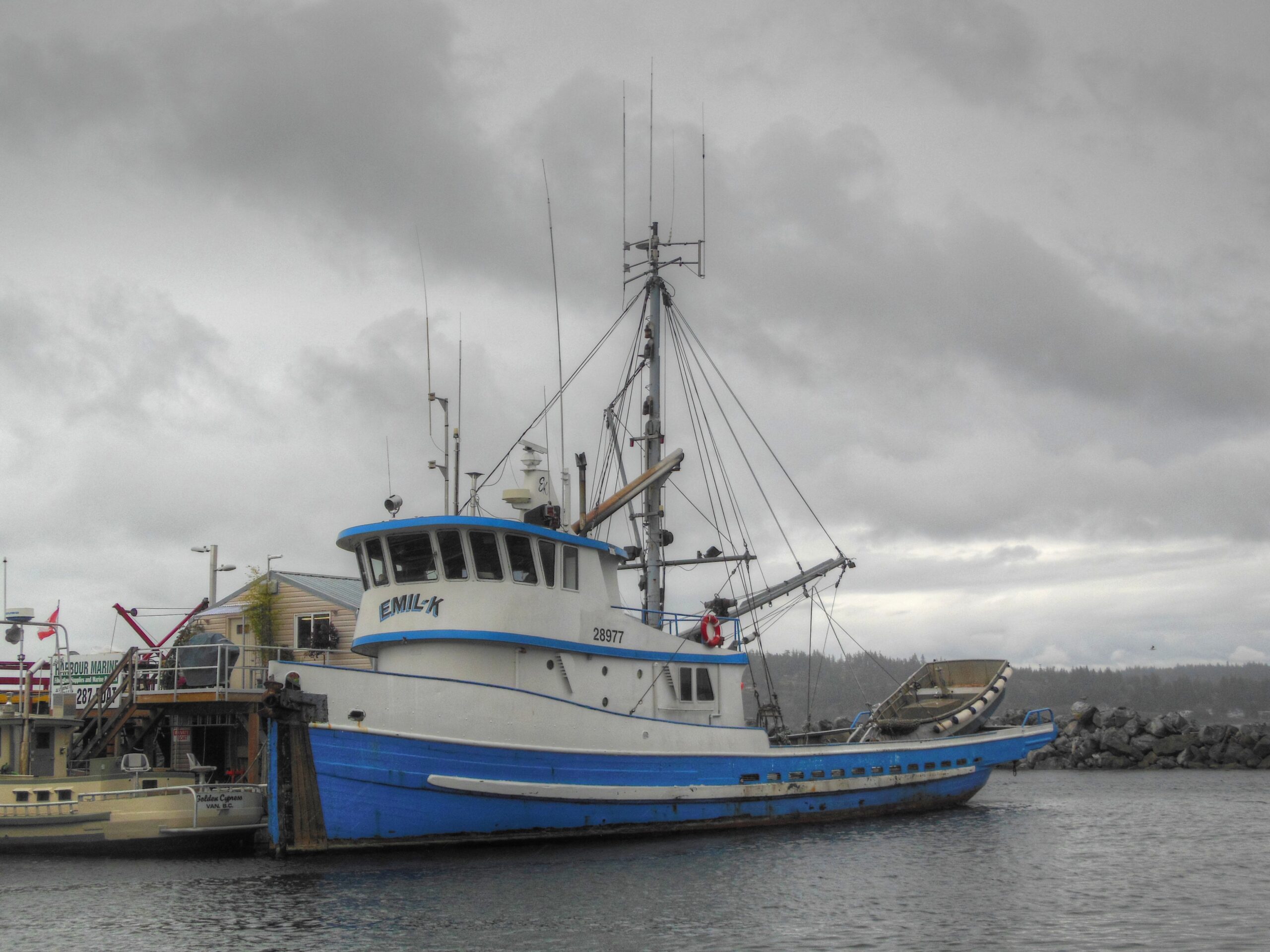
Emil-K

Formerly named the Haidi, the 100 ton drum seiner Emil-K was built in 1941 by Star Shipyards in New Westminster, British Columbia.

Star Shipyards was started in 1908 by Edward Mercer, a Newfoundlander, and his wife, who cleared the lot at 61 Duncan Avenue in Queensborough, a part of New Westminster that extends onto Lulu Island.  The yard was taken over by their sons, Arthur and Gordon Mercer, in the early 1930s.  The yard was sold in 1971 but closed again in 1973.  It was then acquired by Benson Bros., whose shipyard in Coal Harbour was to be acquired for the redevelopment of that neighbourhood, and continued as Benson Star Shipyard until closing again in 1984.  The site at the eastern tip of Lulu Island is still a shipyard, now called Fraser Shipyard & Industrial Centre.

Posted in fishing boats, Georgia Strait, history, ships, Vancouver Island, Vancouver Island Images | Tagged , , , , , , | Leave a comment

Lions in the bay

fbsealions-02

The floats just off the Government Wharf in Fanny Bay are a regular haul out for Stellar and California sea lions.

fbsealions-01 fbsealions-03

Noisy…

Posted in Georgia Strait, marine life, nature, ocean, Vancouver Island, Vancouver Island Images, video | Tagged , , , | Leave a comment

YTL 435

This 422 Class District Harbor Tug, Small was laid down in 1943, at Bellingham Iron Works, Bellingham, WA. She was delivered and placed in service as District Harbor Tug YT-435 in the 12th Naval District, Navy Yard Mare Island in 1944, Vallejo, California, later redesigned as District Harbor Tug, Small YTL-435, and struck from the Naval Register in 1979.

YTL 435,Deep Bay,Tug,US Navy, 422 Class District Harbor Tug

YTL 435 at Deep Bay

  • Displacement: 70 t.(lt) 80 t. (fl)
  • Length: 66′
  • Beam: 18′
  • Draft: 8′ (max.)
  • Complement: 4
  • Propulsion: Hooven-Owen-Rentschler diesel, 375hp @ 872rpm single screw
Posted in Georgia Strait, history, marina, ocean, ships, tugs, Vancouver Island, Vancouver Island Images | Tagged , , , , | Leave a comment

Moorecroft Regional Park

Oops… the post about Moorecroft has been updated and moved here

Posted in Georgia Strait, history, Nanoose, nature, ocean, Vancouver Island, Vancouver Island Images | Tagged , , , , | Leave a comment

Buckley Bay fossils

Buckley Bay,Highway 19A,Highway 19,Island Highway,fossils

A lot of fossils are exposed by the road cut leading from Highway 19 to 19A and the Buckley Bay ferry terminal.

Buckley Bay,Highway 19A,Highway 19,Island Highway,fossils

While the fossils are interesting and easy to find, you have to be careful as the walls of the road cut are somewhat unstable and there’s nowhere along the cut to safely pull off the road. Your best bet is to park uphill in the rest area or downhill at the ferry terminal.

Buckley Bay,Highway 19A,Highway 19,Island Highway,fossils

Buckley Bay,Highway 19A,Highway 19,Island Highway,fossils

Buckley Bay,Highway 19A,Highway 19,Island Highway,fossils

Tres geek – tree cool.

[google-map-v3 shortcodeid=”40ebe02ee5″ width=”630″ height=”350″ zoom=”12″ maptype=”hybrid” mapalign=”left” directionhint=”false” language=”default” poweredby=”false” maptypecontrol=”true” pancontrol=”true” zoomcontrol=”true” scalecontrol=”true” streetviewcontrol=”false” scrollwheelcontrol=”false” draggable=”true” tiltfourtyfive=”false” enablegeolocationmarker=”false” enablemarkerclustering=”false” addmarkermashup=”false” addmarkermashupbubble=”false” addmarkerlist=”49.5250° N, 124.8486° W{}6-default.png” bubbleautopan=”true” distanceunits=”miles” showbike=”false” showtraffic=”false” showpanoramio=”false”]

Posted in nature, Vancouver Island, Vancouver Island Images | Tagged , , , , | Leave a comment

Jellyfish

Jellyfish – love them or hate them they are here to stay. While contact with them can result in a painful sting, they mean us no harm and are beautiful in their own way.

Most of the jellyfish we find along the coast of British Columbia have a much milder sting than those found in tropical waters, and administer a slight sting or none at all. On the other hand, the lion’s mane, Cyanea capillata, can deliver a very painful sting that is very painful, but not  lethal to people under normal circumstances.

jellyfish,Georgia Straight,the beach,marine life,jellyfish of the day,coastal girl

If stung, get out of the water, and then try using a vinegar compress on the area to deactivate any cells still stuck to your skin, and prevent additional stings. The stingers can be picked or scraped off using a stick, towel, or glove, or they can be shaved off with a razor or plastic credit card.

Unseasoned meat tenderizer, or baking soda sprinkled directly onto the skin or mixed into a paste with water can help alleviate the sting, as can flushing the area with large amounts of seawater, or applying a compress of quarter-strength household ammonia. Do not use fresh water or rubbing alcohol, as they can trigger any remaining stingers.

An antihistamine and hydrocortisone cream or ice pack may help control itching and pain.

Posted in Beach, Georgia Strait, marine life, ocean, Vancouver Island, Vancouver Island Images | Tagged , , , , | Leave a comment

Comox Lake – Low water


Comox Lake,Puntledge River recreation area,dam,BC Hydro

I took a trip out to visit the BC Hydro Comox Lake Dam while the level of Comox Lake was low due to maintenance on the Puntledge River Generating Station – this was a good opportunity to see parts of the lake, and the Puntledge River that are normally covered by water.

Comox Lake,Puntledge River recreation area,dam,BC Hydro

Comox Lake has a surface area of  2,100 ha, a maximum depth of 109 m and a mean depth of 61 m – normally the water level is between 136.146 m above sea level (asl), and 130.493 m asl.

Comox Lake,Puntledge River recreation area,dam,BC Hydro

The Comox Dam is a concrete gravity dam, 142 m long, 10.7 m high with a crest elevation of 137.55 m.

Comox Lake,Puntledge River recreation area,dam,BC Hydro

Downstream from the dam


cmlkdamlw

Comox Lake Dam at low water

Remember that this area is located at or near working dams and power stations that contain both natural and man-made hazards. Please play safe and read all posted signs and warnings.

  • Hydroelectric facilities can be dangerous. For your safety, obey all posted signs, and avoid the hazard areas above and below Comox Lake Dam, Puntledge Diversion Dam and the Puntledge Powerhouse.
  • Boaters in Comox Lake reservoir should be aware of shallow channels, exposed stumps and floating debris.
  • Water releases may occur suddenly without warning downstream of the Puntledge River Diversion Dam. This increases currents and creates hazards for recreational river users.
  • If you hear a siren that means the water level is rising fast. Keep out of the river channel area.
Posted in lakes, logging road, nature, Vancouver Island, Vancouver Island Images, video | Tagged , , , | Leave a comment